 On Friday and Saturday I accompanied Brett’s physical geology class from Patrick Henry Community College on a field trip to look at Paleozoic rocks in Botetourt County. One of the stops was an amazing roadcut on US 220 near Eagle Rock (37.641110,-79.806688). The James River cut a gorge through a thick section of Paleozoic sediments here, which was widened with the construction of the highway. About 60 million years of time is exposed in the section, ranging from the Late Ordovician to the Early Devonian.
Eagle Rock is way too complicated to try to describe everything that’s there. According to Gathright and Rader (1981-pdf) it’s a repeated section associated with a large thrust fault to the north, which was then intensely faulted and folded itself. The basic structure is a synclinal fold:
 The sediments themselves are mostly sandstones, although there are interbedded shales and conglomerates. The bulk of the section (including all the rocks in the image above) are nearshore sandstones from the Silurian. There are a few features that enable us to determine which direction was originally up in the rocks (allow it to be identified as a syncline rather than an anticline). For example, there are nice crossbeds in several layers (crossbeds are ripples in cross section):
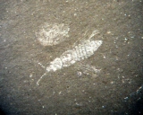
 There are also numerous burrows in some of the beds:
 Structural features are everywhere. Besides the overall large syncline that makes up the mountain, there are many smaller-scale folds:
 Faults are everywhere, and in keeping with the compressional forces dominating the structures here, they are mostly reverse faults:
 In case you’re having trouble seeing it, here’s the same image with the fault marked:
 This small-scale fault is a little easier to see:
 When geologists first arrive at Eagle Rock, they’re immediately drawn to what Gathright and Rader called the “contorted zone”:
 I’m not a structural geologist, so I have no real hope of interpreting this mess. There are folds all over the place, many of which are cut off by faults. Below is my best guess on where some of the faults are located:
 Eagle Rock is a fun outcrop, with a nice mix of trace fossils, sedimentary features, and structural geology, a strewn across a huge swath of geologic time, which is why Brett and I both take students here.
Reference:


Very neat. Thanks for the red lines. They helped!
We’re considering turning this into a low-cost ($10-$20), half-day field trip with a total of three stops. Anyone who would be interested in participating in such a trip should send me an email or post in the comments; if there’s enough interest to make these educational trips financially viable we’ll make them a regular feature.